** Things that I wrote below was exclusively taken from my personal notes / camera, thus miswriting of any technical related issues might occur which I don't give a damn - I considered myself as geo-journalist, I wrote based on what they had mentioned / showed. However I will make comments for some interesting notes that I have. I am hoping to inspire any young geoscientist to be creative but precise in paraphrasing their notes as what I will do now.
Located at Berthoud Hall 241, today at 9 am I attended the Geophysics (GP) Field Camp final presentation. The GP field camp is a mandatory field work course for junior Geophysics students at CSM. This year, students from Imperial College London (ICL) and Boise State University (BSU) are also participating in the field work. There are 50 students in total. Watching the final presentation, for sure, reminded me to GP field works that I have had back when I was undergrad. This 2.5 hrs presentation had great animo from non-participants (like me). There were at least 15 graduate students and 10 faculties in the room.
This year, field camp data is acquired at Neal Hot Springs in Vale Oregon. It involves everything from vibroseismic imaging for basement structure, to near-surface characterization for a better understanding of the geology and geothermal resources. The 4-week program is split somewhat evenly between 2 weeks field work and 2 weeks data processing/interpretation. Back in the day, the Geophysics field work used to run in 8 weeks - WTH !

REGIONAL GEOLOGY
The study area is located in an arid area of eastern Oregon in a setting of complex and intersecting fault trends. A succession of basin fill sediments and intercalated lava flows have been repeatedly broken by episodes of basin formation and extensional faulting. This subsidence and deformational history has resulted in a complex map pattern of intersecting faults and fault blocks comprised of inter-layered sedimentary rocks and lava flows. Within this realm, the most recent faulting appears to have defined a down-faulted half-graben with a basin fill of Late Miocene lacustrine strata faulted against a heavily silicified and brecciated NW-SE striking normal fault. This fault zone is deeply dissected by Cottonwood and Bully creeks. Where the commingled streams cross the fault, defining the lowest exposure in the area, there is a surface hot spring with temperatures approaching boiling. Extensive surface alteration and silicification suggest the hydrothermal system has been in place for a long time, (perhaps millions of years I should say ?? - wild guess). We might guess that the geophysical investigations will be based on the hypothesis that cold meteoric waters arriving by regional drainage are saturating the fault zones in the area and that once waters have descend depths , they will heat to almost boiling and rise through convection and emerge as hot springs ??


Wells location plotted on top of topographic map. Thanks to my junior mate, Gordon Welch, for sharing the jpeg.

Theoretical half graben model (section A-A') at Neal Hot Springs. Thanks to my junior mate, Gordon Welch, for sharing the jpeg.
At the hot springs they encountered white chalky sinter (I have heard silica sinter from Geothermal course with Mr Nukee_boy, but not chalky sinter - any clue?) that are remnants of hydrothermal fluids that have reached the surface. North of the Neal Hot Springs they found surface expression of a normal fault that also appears to have some horizontal displacement. The orientation of the fault is N 15° W / 60°. To the west of the hot springs there are large outcrops of sedimentary rocks. They strike N 15° W and dip 21° in an eastward direction. These rocks are composed of white sediments that may be tuffs (not sure if it's correct, the guy next to me was on call - CRAP!). On top of the sediments there are well rounded volcanic rocks which may be traces of an ancient river (remember Stratigraphy course). Heading south from the sedimentary outcrops they encounter a contact between the sediments and andesites outcrops to the south. This is why Geology is important, mate !


Objectives :
Neal hot springs and the surrounding area contains a variety of rock units and structural features. Potential field techniques depend on contrasts in rock properties, and therefore should be able to locate contacts between formations, and sharp contrasts in rock properties associated with faulting.
Magnetics: To show how magnetic surveys can be used to locate the boundaries between different geologic units and possibly identify the location of faults in the area.
Gravity: To gain an understanding of the regional structure in the area. This is important because the structure will ultimately control how the geothermal system works.


A not too bad forward modeling, tho I will question if it's logic to have such geological model. Too many polygons
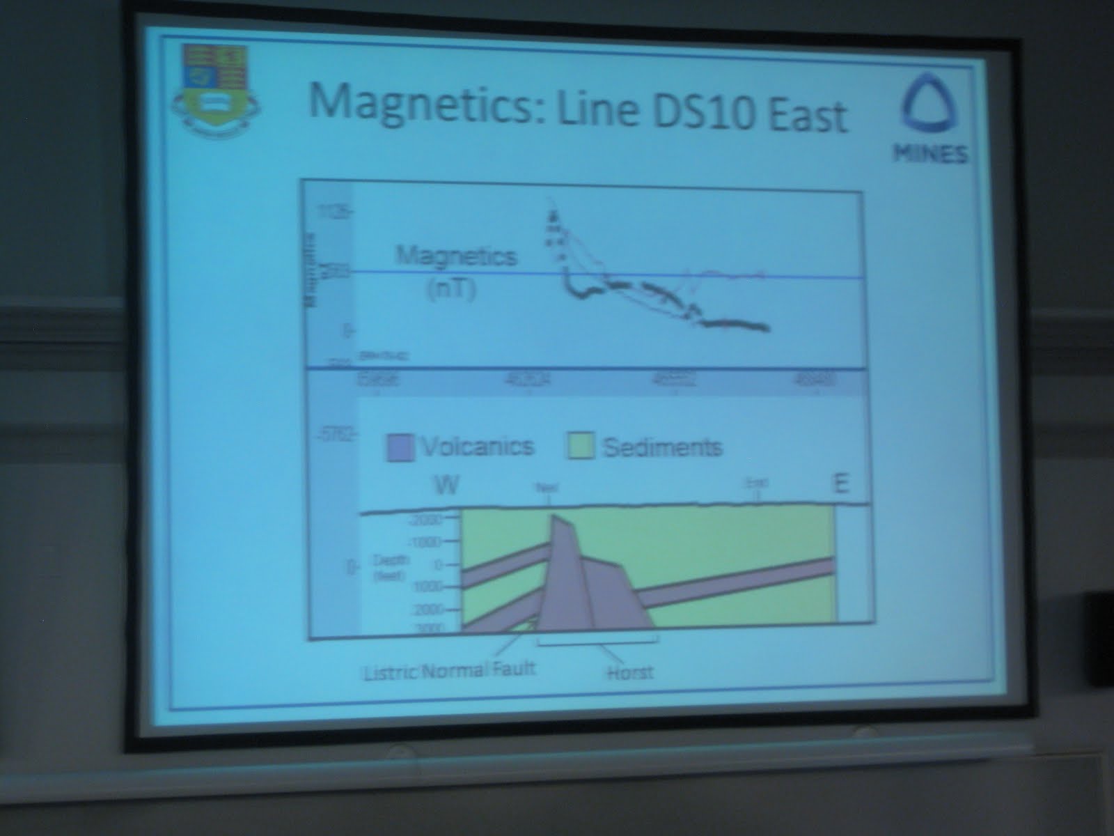
I am not comfortable this magnetic field forward modeling. The mismatch between observed data and forward modeling data is too high. If they are trying to compare it with gravity, they should have recalculated the total magnetic intensity data as if the inducing magnetic field had a 90 inclination (a.k.a reduction to pole = RTP).
Objective : To delineate regional structure surround the target area based on resistivity data.


Great EM inversion. They captured all of frequency band data with no errors. A fault-lookalike featured on the screen. At least we got better regional anomaly than magnetic and gravity do.

GEOELECTRICITY - SELF POTENTIAL
Objectives :
Geoelectrity: Identify the permeable zone candidates surround the area. Two different fashions were done in complementary one to another (Wenner Alpha versus Dipole Dipole). The first configuration has better S/N and better horizontal structure identification. The second configuration has less S/N but better vertical structure identification. Using these configurations together will lead to better delineation of permeable zone.
Self Potential : Investigate the dominant fluid movement based on measured surface streaming potential. The positive versus negative self potential value indicate different type of movement (postive = expulsion, negative = injection / recharge).


3D isoresistivity map - but I don't understand the left handed pic, tho I like the right handed pic better.
Objectives :
Deep seismic survey : basement structure identification
Near surface seismic survey : possible near surface fault/s delineation
Passive seismic survey (monitoring stations) : monitor fault activities, trace fluid motion, earthquakes monitoring
Vertical seismic profiling : vertical velocity mapping on a particular well.
Lacustrine sonar (ultra-seismic) survey : semi-offshore survey, water bottom identification.


wee, ini kayak WS juga po sal ada banyak metode gitu? tapi keknya cuman ngolah data yah? ga akusisi data. kalo liat metodenya sih familiar yah, S1 geopis UGM mestinya juga bisa ini :D
ReplyDeletehaha, like this lah ting .. :)
ReplyDeleteyup ini persis kayak WS, cuma waktu di lapangannya lebih lama ..
ihh wow..keren ya..apik.
ReplyDeletemenyimak.. dan moga2 paham.. (full english T,T)
ReplyDeletehehe, you spend alot of time just for this, and this post really good. then i can compare much with the way me n friend's FC. hahaha... to bad for having modeling like that, but seem they really make it interactive n eyes cathing. that's most important. oke, let's us begin to report our best FC, more good modelling, more fun, more challenging, n best performing presentation.
ReplyDeleteyes - they actually did a great job (hey they're only bunch of juniors !)
ReplyDeleteFey, kuwi gambar half graben-e kowe kan wes ahli (pas pendadaran)
ReplyDelete